


The quake revived memories of the deadly 1992 Flores disaster, when a similarly powerful earthquake unleashed a devastating tsunami that killed more than 2,500 people.
BY PC Bureau
A powerful magnitude 7.7 earthquake struck off the northern coast of Flores in eastern Indonesia early Saturday, sending residents and tourists fleeing buildings, damaging structures and triggering a tsunami warning across several Indonesian provinces.
The U.S. Geological Survey said the earthquake struck at about 5:58 a.m. local time at a shallow depth of around 10 kilometres, with the epicentre about 68 kilometres north-northwest of Ende in East Nusa Tenggara province. The shallow depth intensified the shaking across Flores and surrounding areas.
The earthquake was followed by a series of powerful aftershocks, including tremors in the magnitude 5 to 6 range, keeping residents out of their homes and emergency agencies on high alert.
Indonesia’s Meteorology, Climatology and Geophysics Agency, BMKG, issued a tsunami warning for parts of East Nusa Tenggara, West Nusa Tenggara, South Sulawesi and Southeast Sulawesi. Residents in vulnerable coastal areas were urged to immediately move to higher ground and stay away from beaches and riverbanks.
The warning sparked scenes of panic in several communities. Residents rushed into streets and open spaces while tourists evacuated hotels and other buildings amid violent shaking.
Buildings damaged, roads cut off
The full scale of the destruction was still being assessed, but preliminary reports from Flores indicated damage across several regencies.
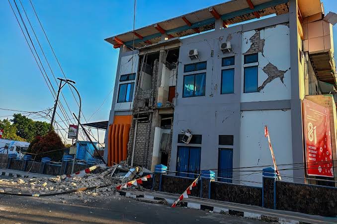
In Labuan Bajo, one of the island’s major tourist centres, the Hotel Jayakarta reportedly suffered damage to its lobby, walls, furniture and fittings. Other buildings, including churches, schools and public facilities, were also reported to have sustained damage. Cracks appeared in walls and parts of some structures reportedly collapsed.
The earthquake caused particular alarm among tourists, many of whom rushed out of hotels as buildings shook.
In Maumere, the waiting room at the Pelni port reportedly collapsed, with other sections of the port complex also damaged.
In Ruteng and surrounding Manggarai areas, buildings including the campus of Unika Ruteng were reportedly damaged. A landslide blocked the road between Ruteng and Waelengga, cutting off an important road link and complicating access for emergency teams.
Reports from Manggarai Timur indicated that several bridges were damaged, while houses in rural and remote villages suffered heavier destruction. Some multi-storey structures were reportedly damaged or partially collapsed, while furniture and household possessions were thrown around by the violent shaking.
A BRI bank building in the Borong area was also reported to have been destroyed.
The reports remain preliminary and have not yet been consolidated into an official nationwide damage assessment. Authorities are expected to provide a clearer picture as emergency and assessment teams reach affected communities.
Tsunami generated, but waves remained relatively small
The earthquake triggered fears of a repeat of Flores’ devastating 1992 disaster, when a major earthquake generated a deadly tsunami.
Saturday’s tsunami, however, appears to have been considerably smaller.
Tide gauges recorded a wave of about 0.94 metres at Maurole in Ende, while waves of roughly 0.36-0.38 metres were recorded around Labuan Bajo and parts of Sikka. Smaller waves were observed at other locations.
Australia’s tsunami warning authorities said there was no tsunami threat to Australia’s mainland or territories.
The Indonesian warning nevertheless prompted residents along vulnerable coastlines to evacuate as a precaution.
No confirmed deaths reported so far
There were no confirmed deaths or injuries in the immediate reports available several hours after the earthquake. Indonesian disaster-management authorities continued to assess affected areas, meaning the casualty and damage figures could change as communications are restored and emergency workers reach remote villages.
The absence of an immediate confirmed death toll does not mean the disaster has been fully assessed. Flores contains numerous mountainous and remote communities where landslides, blocked roads and damaged communications can delay reports.
Authorities have warned residents to remain alert because strong aftershocks can cause additional collapses in buildings already weakened by the main earthquake.
READ: Rodents, Cockroaches and Expired Food: FDA Suspends Blinkit, Zepto, Instamart Licences
A powerful 7.7 magnitude quake just slammed Indonesia near Ende – Tsunami Warning Issued
Prayers for everyone affected.#Indonesia pic.twitter.com/pfC2dioTXb— Roberto Gil (@RbtGil) August 14, 2026
Why Indonesia is so earthquake-prone
Indonesia sits in one of the world’s most tectonically active regions, where several major tectonic plates interact. It is commonly associated with the Pacific “Ring of Fire”, the roughly 40,000-kilometre horseshoe-shaped belt surrounding much of the Pacific Ocean that contains numerous active volcanoes and earthquake zones.
The Ring of Fire is not a single giant geological structure. It is a collection of different plate boundaries. Along many of them, one tectonic plate is forced beneath another in a process known as subduction.
When plates become locked, enormous stresses can accumulate over years or centuries. Eventually the rocks rupture or slip, releasing the stored energy as an earthquake.
Subduction zones are particularly capable of producing powerful earthquakes because huge sections of the Earth’s crust can become locked together before suddenly breaking loose. They are also associated with deep ocean trenches and volcanic arcs.
Indonesia’s location near the complex boundary between the Australian, Sunda and other regional plates makes it especially vulnerable to earthquakes, volcanic eruptions, landslides and tsunamis.
WATCH – 🇮🇩 Footage captures the intense moments of Indonesia’s 7.7-magnitude earthquake, showing buildings shaking as people flee in panic. pic.twitter.com/gnYk5i1UCV
— Political Pen (@politicalpen_) August 14, 2026
Flores remembers the catastrophe of 1992
The current earthquake has revived memories of one of Indonesia’s deadliest seismic disasters.
On December 12, 1992, a magnitude 7.7 earthquake struck the Flores region. Although similar in magnitude to Saturday’s earthquake, its consequences were vastly more catastrophic because it generated a destructive tsunami.
USGS records put the 1992 death toll at about 2,500, making it Indonesia’s deadliest earthquake of that year.
Research into the disaster found that nearly all of the deaths in the Flores region were associated with the tsunami rather than the earthquake shaking itself. The tsunami reached extraordinary heights in some locations, with studies documenting waves as high as about 25 metres. At Maumere, roughly 90% of buildings were destroyed, while between 50% and 80% of structures across parts of Flores were damaged or destroyed.
The 1992 disaster also left tens of thousands of people homeless and devastated infrastructure, including hospitals, homes and port facilities.
1992 vs 2026
| 1992 Flores disaster | 2026 Flores earthquake | |
|---|---|---|
| Magnitude | About 7.7 | 7.7 |
| Depth | About 28 km | About 10 km |
| Tsunami | Devastating | Relatively small waves reported |
| Deaths | About 2,500 | No confirmed deaths in initial reports |
| Worst-hit areas | Maumere, Babi and parts of Flores | Damage reported across several Flores areas |
| Buildings | Massive destruction; up to 90% destroyed in Maumere | Preliminary reports of structural damage and collapses |
| Main secondary hazard | Major tsunami and landslides | Aftershocks, landslides and limited tsunami |
The contrast is stark: two earthquakes of broadly comparable magnitude can produce dramatically different consequences. The 1992 disaster demonstrated that the danger from a major offshore earthquake is not limited to ground shaking. A tsunami can multiply the death toll and destruction within minutes.
One reason the 1992 event produced such an unusually destructive tsunami may have been submarine landsliding, according to research into the disaster.
Authorities remain on alert
Emergency authorities are continuing to inspect buildings, roads, bridges, ports and other infrastructure. The biggest immediate concerns are further collapses, landslides and strong aftershocks.
Residents have been urged not to return prematurely to damaged buildings and to rely on official information from BMKG, BNPB and local disaster-management agencies.
For Flores, the memory of 1992 makes every major offshore earthquake particularly frightening. Saturday’s tsunami appears to have been far smaller than the wave that devastated the island more than three decades ago, but the extensive preliminary reports of structural damage and widespread panic underline the vulnerability of communities living in one of the world’s most seismically active regions.