


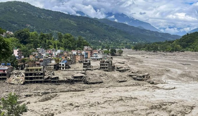
With hundreds dead or missing, the competing accounts have intensified questions over the exact origin of the disaster and whether stronger cross-border warning systems could have helped prevent the scale of the tragedy.
BY PC Bureau
August 27, 2026: China on Thursday rejected Nepal’s claim that the collapse of a “geological disaster dam” on the Chinese side of the border triggered the devastating flash floods in the Rasuwagadhi-Kerung region, calling the allegation “fake news” and denying that it had failed to issue an early warning.
The Chinese Embassy in Kathmandu said the disaster was instead triggered by a geological event on the Nepali side. In a statement posted on Facebook, the embassy said an earthquake or earthquake-like glacial collapse in Nepal on the morning of August 26 had triggered massive mudslides, causing deaths and leaving people missing on both sides of the Gyirong-Rasuwagadhi border.
“Accusation helps nothing” and “cooperation saves lives,” the embassy said, urging the two countries to focus on search, rescue and relief rather than assigning blame.
The Chinese statement came amid growing questions in Nepal over the origin of the flood and whether authorities on the Chinese side had provided adequate warning before the torrent swept into Nepal.
Nepal and China have since agreed to strengthen the exchange of meteorological information. Nepal’s Department of Hydrology and Meteorology said the Chinese side had agreed to immediately notify Nepal of any meteorological risk or impact that could affect its territory. Officials also said there had been no significant rainfall recorded in the affected areas on either side of the border, adding that further investigation was needed to establish the precise cause of the flood.
The latest scientific evidence has complicated the early theories about the disaster. The US Geological Survey initially recorded a magnitude 4.4 seismic event near the Nepal-China border at about 8:37am on August 26. After analysing additional seismic stations, long-period waves and satellite imagery, it revised the event to magnitude 5.2 but concluded that it was not an earthquake.
According to the USGS, the seismic signal was generated by a glacial collapse and debris flow, which then caused catastrophic downstream flooding.
One of the first thing Chinese government report is that the flood only affect Nepal or seems to guide us to think that way.
There is also a massive censorship campaign on the issue. That is despite the whole Chinese side check point was swept away along with the Nepalese… pic.twitter.com/TiDKGEOKbA
— The Great Translation Movement 大翻译运动 (@TGTM_Official) August 27, 2026
The distinction is important. The USGS finding supports the view that a massive collapse of ice, rock and debris triggered the flood, but it does not by itself establish where the collapse occurred or settle Nepal’s separate allegations concerning a “geological disaster dam” or the failure to issue an early warning. Satellite and geological investigations are continuing to determine exactly where the ice and rock failed and how the resulting surge travelled towards the border.
Reuters reported that satellite imagery showed a substantial section of a glacier at an altitude of about 5,200 metres breaking away and crashing into a valley more than 1,200 metres below. The resulting ice-rock avalanche sent a huge surge of water, mud and debris into the Bhote Koshi and Trishuli river systems.
The disaster devastated settlements and infrastructure on both sides of the border. Roads, bridges, buildings and hydropower installations were damaged or destroyed, while hundreds of people remained missing. Nepal’s authorities had recovered at least 157 bodies by Wednesday night, with the toll continuing to rise as rescue teams searched downstream areas.
The scale of the disaster has also raised questions about cross-border early-warning mechanisms. A major road linking Nuwakot to the Rasuwagadhi border was damaged at multiple points, while several bridges were swept away. The Department of Roads said the entire 42-kilometre stretch between Betrawati and Rasuwagadhi had been damaged by the flood.
For now, the competing claims over the disaster’s origin remain unresolved. China insists that allegations of a dam collapse and failure to warn Nepal are false, while Nepalese authorities and experts continue to examine how the sudden torrent formed and whether information available on the Chinese side could have enabled an earlier warning.
READ: Nepal Flood: 400 Kailash Pilgrims Out of Contact; 77 From Sadhguru’s Group in Tibet
What is clear is that the disaster was driven by an extraordinary geological event involving a massive glacial or ice-rock collapse and debris flow. The immediate priority for both countries remains rescuing survivors and accounting for the hundreds still missing.
The disaster has also exposed the vulnerability of communities and pilgrims living and travelling along one of the Himalayas’ most hazardous cross-border corridors—and the urgent need for a more effective Nepal-China system for sharing real-time geological, hydrological and meteorological warnings.