

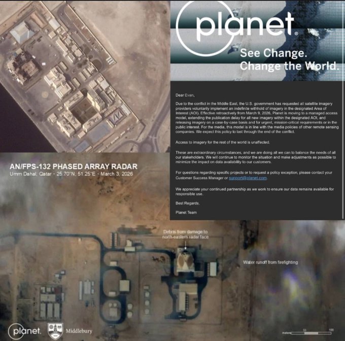
Planet Labs confirmed it will indefinitely withhold images dating back to March 9, shifting to selective release under a “managed distribution” system.
BY PC Bureau
April 5, 2026 : The United States government has requested commercial satellite firms to limit access to imagery of Iran and key conflict zones in the Middle East, a move that is raising concerns about transparency and the ability to independently assess the scale of war damage.
California-based satellite imaging company Planet Labs confirmed that it will indefinitely withhold satellite visuals of Iran and surrounding areas following a request from U.S. authorities. The restriction applies to imagery dating back to March 9 and is expected to remain in force for the duration of the conflict.
The development, first reported by Reuters, indicates that the request was not limited to a single company. According to Planet Labs, the U.S. government urged all commercial satellite imagery providers to adopt similar restrictions, effectively reducing the availability of near real-time visuals from the war zone.
The cover up of military failure grows
The US regime has compelled Planet Labs and other satellite imagery companies that contract with it (like Vantor) to censor images exposing US and Israeli losses https://t.co/uCnkvaQV5g
— Max Blumenthal (@MaxBlumenthal) April 4, 2026
In a notice to its clients, the company said it would transition to a “managed distribution” model, under which imagery would be released selectively. Access will be granted on a case-by-case basis, primarily for “mission-critical” needs or where there is a clear public interest, while ensuring that sensitive information that could pose a security risk is withheld.
The decision expands on an earlier 14-day delay on imagery from the Middle East, introduced last month. At the time, Planet Labs said the delay was intended to prevent adversaries from using commercially available satellite data to support military operations against the United States and its allies.
The Pentagon has declined to comment on the matter, reiterating its standard policy of not discussing intelligence or operational decisions.
Strategic Rationale
Satellite imagery has become a central component of modern warfare, enabling capabilities such as target identification, damage assessment, troop movement tracking, and missile guidance. Open-access commercial imagery, in particular, has significantly changed how conflicts are monitored, allowing not only governments but also journalists, researchers, and independent analysts to observe developments in near real time.
Security experts say restricting such imagery can serve legitimate military objectives. By limiting access, governments can reduce the risk of adversaries exploiting up-to-date visuals to identify targets, assess vulnerabilities, or plan counterattacks.
However, the same imagery also plays a crucial role in documenting the humanitarian and infrastructural impact of war.
Concerns Over Transparency
The move has sparked debate among media organizations, open-source intelligence (OSINT) analysts, and human rights groups, who rely heavily on satellite data to verify claims made by governments and militaries.
With limited access to independent imagery:
- Verification of airstrikes and battlefield outcomes becomes more difficult
- Civilian casualty assessments may rely more heavily on official statements
- Documentation of damage to infrastructure, including hospitals and residential areas, could be constrained
Analysts warn that such restrictions may create an “information gap,” where governments retain access to detailed intelligence while the public and independent observers face reduced visibility.
“This kind of control over imagery can significantly shape the narrative of a conflict,” said one geopolitical analyst, noting that visual evidence has become a powerful tool in influencing global opinion.
READ: Iran Praises Pakistan’s Peace Push, Says No Rift with Islamabad
Impact on Journalism and Research
Commercial satellite data has been widely used in recent years to investigate conflicts, from tracking troop buildups to identifying destroyed infrastructure in remote or restricted regions. News organizations and academic institutions often depend on these images to corroborate on-the-ground reports.
The restrictions imposed by Planet Labs and potentially other providers could complicate such efforts, particularly in areas where independent reporting is already limited due to security risks.
While the company has said it will continue to release imagery in cases deemed to be in the public interest, the lack of clarity around how such decisions will be made has raised further questions.
Balancing Security and Public Access
In its statement, Planet Labs described the situation as “extraordinary,” emphasizing that the measures are intended to balance national security considerations with the needs of customers and stakeholders.
The company did not respond to further requests for comment.
The U.S. government has not publicly detailed the scope of its request or whether formal directives were issued, but the reported coordination across satellite firms suggests a broader effort to control the flow of geospatial intelligence during the conflict.
Broader Implications
The development highlights a growing tension in modern warfare between operational security and information transparency. As commercial satellite networks expand and provide increasingly detailed coverage of global events, governments are facing new challenges in managing what information becomes publicly accessible.
Experts say the current situation could set a precedent for how satellite data is handled in future conflicts, particularly as reliance on private-sector intelligence continues to grow.
For now, with imagery access curtailed and official information limited, independent assessment of the war’s full impact may remain significantly constrained.