


High-resolution satellite images recently released indicate that India’s airstrike on Pakistan’s Murid Air Base on May 10 during Operation Sindoor may have aimed at a suspected underground site.
Satellite images obtained from Maxar Technologies reveal a nearly 3-meter-wide crater located just 30 meters from the entrance of a heavily secured sub-complex at the Murid Air Base—an area safeguarded by double fencing, surveillance towers, and stringent security measures.
Damien Symon, a geo-intelligence researcher at the Intel Lab, notes that the crater’s closeness to a suspected underground structure has fueled speculation that India’s intention was to target deeply buried assets, potentially associated with command-and-control operations or drone activities.

ALSO READ: US Ends Routine Child, Pregnant Woman COVID Shots Amidst Safety Concerns
Precise-guided weapons used in Operation
The attack seems to have compromised the boundary defenses of this critical area, suggesting the utilization of precision-guided weapons and deep-targeting strategies. If verified, this would mark the first known case of India trying to disrupt underground military facilities in Pakistan.
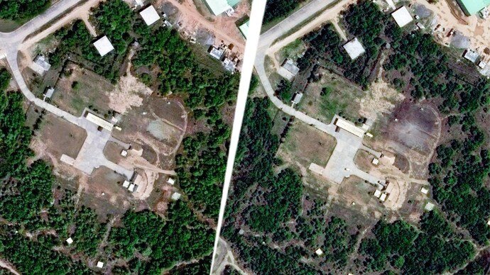
In another part of the base, signs of damage can be seen on the roof of what seems to be a command-and-control facility next to a UAV complex and hangar. The roof displays evident signs of damage, with evidence of internal issues, indicating a direct hit, stated Symon.
In the meantime, subsequent Maxar images of Nur Khan Air Base, which was also affected during Operation Sindoor, show a damage footprint that is larger than originally assessed.
The Murid air base is located 150 kilometers away from the Line of Control in Jammu and Kashmir. It is located in Chakwal, Pakistan, providing assistance to the Sargodha air base and the Nur Khan air base in Rawalpindi.
Both were hit by India on May 10, together with eight additional bases. India launched a deep strike into Pakistan, and its reaction was “measured and calibrated.”